Hurricane Melissa strengthens; nears category 2 status
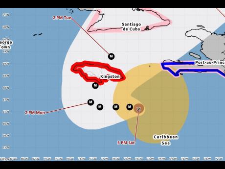
The Meteorological Service says Hurricane Melissa continues to rapidly intensify with maximum sustained winds increased to near 150 kilometres per hour (90 mph), putting it close to being a category 2 storm.
Rapid intensification is forecast to continue over the next day or so, and Melissa is expected to become a major hurricane by Sunday, posing an extremely high threat to the island.
A Hurricane Warning remains in effect for Jamaica. A hurricane warning means that within the next 36 hours or less Jamaicans should expect dangerously high water or a combination of dangerously high water and exceptionally high waves, even though winds expected may be less than hurricane force as well as an average winds of 64 knots (119km/h) or higher.
As of 4 p.m. the centre of Hurricane Melissa was located about 162 kilometres (101 miles) south-southeast of Morant Point, or 210 kilometres (130 miles) southeast of Kingston. Hurricane-force winds extend outward up to 30 km (15 miles) from the centre, the Met Office said.
Melissa is moving slowly west-northwest near 6 km/h (3 mph). A slow westward motion is expected through the rest of the weekend, followed by a turn to the north and northeast on Monday and Tuesday.
The public is urged to prepare for life-threatening conditions.
Expected rainfall amounts of 350 to 650 millimetres (15 to 25 inches) over parts of Jamaica in the next few days, making catastrophic flash floods and landslides likely.
The met offie says a dangerous storm surge is becoming more likely along the south coast of Jamaica later in the weekend or early next week. Peak storm surge heights could reach 7 to 11 feet above ground level near and east of where the centre is expected to make landfall.
Tropical storm-force winds are expected to initially affect the island, mainly over eastern parishes by tonight, with hurricane conditions expected by Sunday or Monday.
Small craft operators, including fishers on the cays and banks, are strongly advised to remain in safe harbour.
The Meteorological Service says the next bulletin will be issued at 8 p.m. For recorded updates, dial 116.
--
Hurricanes and their categories: United States National Hurricane Center
Hurricanes are ranked using the the Saffir-Simpson Hurricane Wind Scale, which has a 1 to 5 rating based only on a hurricane's maximum sustained wind speed. This scale does not take into account other potentially deadly hazards such as storm surge, rainfall flooding, and tornadoes.
The Saffir-Simpson Hurricane Wind Scale estimates potential property damage. While all hurricanes produce life-threatening winds, hurricanes rated Category 3 and higher are known as major hurricanes.
Major hurricanes can cause devastating to catastrophic wind damage and significant loss of life simply due to the strength of their winds. Hurricanes of all categories can produce deadly storm surge, rain-induced floods, and tornadoes. These hazards require people to take protective action, including evacuating from areas vulnerable to storm surge.
*In the western North Pacific, the term "super typhoon" is used for tropical cyclones with sustained winds exceeding 150 mph.
Category 1
Sustained winds: 74-95 mph (119-153 km/h)
Very dangerous winds will produce some damage: Well-constructed frame homes could have damage to roof, shingles, vinyl siding and gutters. Large branches of trees will snap and shallowly rooted trees may be toppled. Extensive damage to power lines and poles likely will result in power outages that could last a few to several days.
Category 2
Sustained winds: 96-110 mph (154-177 km/h)
Extremely dangerous winds will cause extensive damage: Well-constructed frame homes could sustain major roof and siding damage. Many shallowly rooted trees will be snapped or uprooted and block numerous roads. Near-total power loss is expected with outages that could last from several days to weeks.
Category 3 (major)
Sustained winds: 111-129 mph (178-208 km/h)
Devastating damage will occur: Well-built framed homes may incur major damage or removal of roof decking and gable ends. Many trees will be snapped or uprooted, blocking numerous roads. Electricity and water will be unavailable for several days to weeks after the storm passes.
Category 4 (major)
Sustained winds: 130-156 mph (209-251 km/h)
Catastrophic damage will occur: Well-built framed homes can sustain severe damage with loss of most of the roof structure and/or some exterior walls. Most trees will be snapped or uprooted and power poles downed. Fallen trees and power poles will isolate residential areas. Power outages will last weeks to possibly months. Most of the area will be uninhabitable for weeks or months.
Category 5 (major)
Sustained winds: 157 mph or higher (252 km/h or higher)
Catastrophic damage will occur: A high percentage of framed homes will be destroyed, with total roof failure and wall collapse. Fallen trees and power poles will isolate residential areas. Power outages will last for weeks to possibly months. Most of the area will be uninhabitable for weeks or months.
Follow The Gleaner on X, formerly Twitter, and Instagram @JamaicaGleaner and on Facebook @GleanerJamaica. Send us a message on WhatsApp at 1-876-499-0169 or email us at onlinefeedback@gleanerjm.com or editors@gleanerjm.com.

