Neil Richards | Consequences of building on very dangerous sites
Loading article...
-
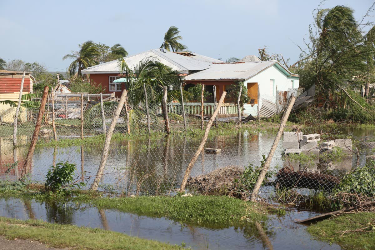 This 2024 photo shows houses in Portland Cottage damaged by Hurricane Beryl.
-
 Neil Richards
There is a fatal attraction to the practice of building on dangerous sites that seem to be ‘easy pickings’ for unauthorised occupation. Persons who squat on public or private land, seem to be embolden with confidence that the authorities will be tardy in preventing such occurrences. Public perception of sloppy oversight by the authorities, stains the reputation of officials who aggressively pursue and deter actions that are obviously dangerous and would contribute to environmental ugliness.
What frequently comes in mind, and feeds perceptions of sloppy oversight, is tolerance of long-term occupancy of ‘captured lands’ on which fragile accommodations are highly vulnerable to extreme weather events – in communities where residents are presumed to have reputations for dangerous pursuits unrelated to bad weather conditions.
In the aftermath of Hurricane Melissa, aerial surveillance exposed land-use waywardness on a grand scale. Large expanses of south-coast beach-front lands are the site of structurally unsafe buildings used as residential accommodations and for unregulated commerce. The extent of damage to seemingly substantial civic and commercial buildings – by the recent ‘Category 5’ hurricane, is a shocking revelation of widespread structural deficiencies.
Water-logged, low-lying sites are typical of several south coast locations – including the environs of the Yallahs ponds, Old Harbour Bay, Portland Cottage, and other sites along the Clarendon coast, St. Elizabeth coast and the Westmoreland coast. Those locations need unique solutions to minimise the impact of storm surges.
Future architectural and engineering solutions for selected public buildings in severely flood-prone locations, may focus on design options with the lowest floor several feet above ground-level. Hurricane resistant roofs would be an integrated necessity.
In a category vastly different from ‘sidewalk vending’ and ‘captured lands’, are the following dangerous outcomes related to the location of high-profile projects:
• Discharge of toxic, industrial waste into nearby rivers which has repeatedly decimated aquatic life in St Catherine and other locations.
• Destruction of mangroves in the vicinity of tourism-related projects has had dangerous impacts on the habitat of some marine species.
• Damage to coral reefs in the vicinity of shoreline construction, has significantly reduced the role of such reefs in reducing the impact of dangerous storm surges.
• Erosion of soil from steep slopes, and flooding caused by excessive overlay of asphalt and concrete on ‘former’ absorptive soil, are dangerous occurrences.
• Major flooding from underground water-sources have ‘erupted’ periodically at inland locations – such as Moneague in St. Ann, Newmarket in St. Elizabeth, Content near Porus in Manchester, and Success in Hanover.
It has been 74 years since the severe consequences of Hurricane Charlie spurred the colonial government of Jamaica to introduce the following major initiatives :
1. The Sandy Gully drainage system of Kingston & St. Andrew was constructed in the 1950s, and is a proven, major engineering achievement.
2. Another major accomplishment in the aftermath of Hurricane Charlie was preparation of urban development guidelines that were introduced to facilitate the orderly and progressive development of parish-capitals and coastal sites with significant tourism potential. Those groundbreaking proposals were introduced by British town planning and architecture experts David Spruell and Graeme Hodges. Their pioneering contributions guided the work of the Town Planning Department (TPD) for many years, and continue to have meaningful impacts.
Strong continuity of bold urban development initiatives were pursued by Government Minister of Development, Edward Seaga, in the 1960’s. During that decade, National Physical Development Plans were prepared by personnel of the United Nations Development Programme (UNDP). In addition to those comprehensive plans, international firm – Shankland Cox Overseas prepared urban design proposals for the Kingston Waterfront and Ocho Rios Waterfront.
New land-use directions are now urgent, and should ideally be piloted by a re-structured National Environment & Planning Agency (NEPA). Robust town planning initiatives are necessary – in the framework of long-term plans of 50 years.
Robust engineering specifications and keen construction-oversight focused on preventing easy destruction of vital infrastructure (roads, schools, hospitals and other community facilities) are also urgent requirements.
In the aftermath of Hurricane Melissa, unqualified workmen are no doubt promoting themselves as general contractors – which is a recipe for physical destruction and loss-of-life in another extreme weather event.
The future calls for bold approaches with a focus on substantive programmes and solutions in the public interest.
Neil Richards is an architect and town planner. Send feedback to columns@gleanerjm.com.